This document is provided for general informational purposes only and does not constitute legal, tax, accounting, insurance, brokerage, risk management, or other professional advice. You should consult your own legal counsel or other qualified professional advisors regarding your specific circumstances, and receipt of this document does not create any client, advisory, fiduciary, brokerage, or other professional relationship with Alliant Insurance Services, Inc. This document is provided “as is” without warranty of any kind, and Alliant Insurance Services, Inc. disclaims any liability for any loss or damage arising out of or relating to reliance on this document.
Insight
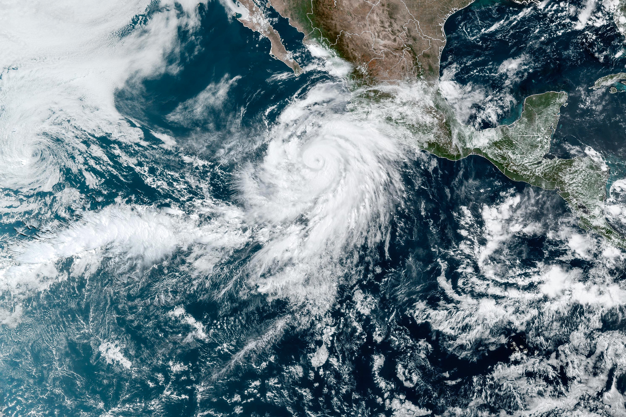
Hurricane Hilary Alliant Bulletin
By Alliant Property & Casualty
Current status of Hurricane Hilary (as of 3:00 PM MDT, Aug 18, 2023)
- Location: Near Socorro Island, latitude 18.2N, longitude 111.8W.
- Distance: 60 miles WSW of Socorro Island and 360 miles SSW of Cabo San Lucas, Mexico.
- Winds: Maximum sustained winds of 145 mph (230 km/h).
- Movement: NW at 10 mph (17 km/h).
- Pressure: Minimum central pressure of 939 mb (27.73 inches).
Watches and Warnings
- Hurricane Warning: Baja California peninsula from Punta Abreojos to Punta Eugenia.
- Hurricane Watch: Baja California peninsula north of Punta Eugenia to Ensenada.
- Tropical Storm Warning: Several areas in Baja California and mainland Mexico.
- Tropical Storm Watch: Various regions including the Baja California peninsula north of Loreto, Mainland Mexico north of Huatabampito, and parts of California.
- Explanations provided for each type of watch and warning.
Discussion and Outlook
- Path: A north-northwest movement expected with a close approach to Baja California over the weekend and reaching southern California by Sunday night.
- Intensity: Category 4, with fluctuations likely and gradual weakening starting Saturday.
- Wind Field: Hurricane-force winds extend up to 45 miles from the center, and tropical-storm-force winds extend up to 290 miles.
- Forecast Details: Satellite data shows an impressive major hurricane with potential signs of a double eyewall structure.
Hazards Affecting Land
- Rainfall: 3 to 6 inches across portions of the Baja California Peninsula, with localized 10 inches possible. Similar amounts expected in southern California and Nevada with significant flooding risks.
- Wind: Hurricane and tropical storm conditions expected in various warning and watch areas.
- Storm Surge: Coastal flooding anticipated along the western Baja California peninsula with large and destructive waves.
- Surf: Life-threatening surf and rip current conditions expected along southwestern Mexico and Baja California.
Additional Discussion
- Hilary's intensity has leveled off after a 70-kt increase in winds, remaining a major hurricane.
- Hilary is quite large with tropical-storm-force winds extending up to 250 nautical miles from the center.
- Hilary's motion is northwest and is expected to move near the Baja California Peninsula coast Saturday night and then inland over southern California Sunday night.
- Weakening is anticipated as the hurricane moves over cooler sea surface temperatures (SSTs), increased shear, and drier air.
- This is the first time the NHC has issued a Tropical Storm Watch for southern California.
- Key messages include warnings about heavy rainfall leading to flash flooding, hurricane and tropical storm conditions, and large swells affecting coastal areas.
Forecast Positions and Max Winds
- Forecast details provided for the next 96 hours, culminating in dissipation by 22/1200Z.
The report details the significant impact Hurricane Hilary is expected to have over Baja California and parts of southwestern U.S., including southern California. Preparations are being urged due to the potential for dangerous flooding, high winds, and storm surge. Monitoring the storm's progress and heeding local advisories is emphasized.
For more information please visit Alliant Disaster Recovery.

